001 - Introduction
Survey Air is a team of surveyors and licensed UAV pilots, backed by RICS expertise, delivering professional drone services in the UK.
Our expert team combines surveying proficiency and the latest drone technology, providing highly efficient UAV services across many industries. We communicate effectively, adhere to professional standards and tailor our solutions to meet your specific project requirements.
002 - Services
Unlock the benefits of cutting-edge drone technology
We specialise in advanced UAV data collection, supporting a diverse range of surveying, mapping and media projects.

Roof and high-level inspections, tailormade for surveyors and property maintenance, for accurate data, rapid delivery and condition reporting.
- Low-cost drone surveys
- Fast and efficient delivery
- RICS inspection procedures
- Supplementary location map
Enterprise data collection using UAV imaging technologies, including Photogrammetry, LiDAR, and Multispectral, for a wide range of industry applications.
- Complex UAV missions
- Accurate geospatial data
- Common industry exports
- Customised GIS solutions


UAV expertise combined with artistic vision to deliver engaging video content that promotes your business, projects or events.
- Specialist FPV drone pilots
- Immersive marketing content
- Professional video editing
- Video production retainers
003 - Process
Plan and execute UAV missions with confidence
From planning to operation and final data delivery, we provide specialist UAV surveying and mapping solutions.

01
Planning
We assess your site, define objectives, and plan complex UAV missions to ensure accurate data capture.

02
Operations
Our skilled drone pilots conduct safe and compliant drone surveys, capturing high-quality imagery and spatial data.

03
Delivery
We process and analyse the data, providing actionable insights and UAV outputs tailored to your project needs.
004 - About
Survey Air was formed to help the profession understand and adopt UAV solutions that deliver real value.
We're committed to upholding the highest industry standards, and our partnership with the Royal Institution of Chartered Surveyors is a testament to that dedication. As part of this program, we pledge to adhere to their rigorous code of conduct, ensuring professionalism, integrity, and quality in all our services.
005 - Journal
Here, you'll find a wealth of information about the latest in drone technology, where we share case studies, industry news, and tips and tricks for harnessing the power of drones (UAVs).
Our team of experts have years of experience in the field, and we're passionate about using technology to support and benefit a wide range of clients and sectors.
We really enjoy sharing our knowledge and experience with you, so you can stay up-to-date on the latest news and trends.

A Guide to Cinematic and FPV Drone Media Production
Drone cinematography has progressed from a cinematic novelty into a core component of professional aerial media production. Once limited to…
Read Article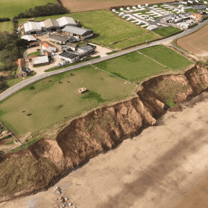
Mappleton UK Coastal Erosion Study: Revisited
Following our initial Mappleton coastal erosion survey in late 2024, Survey Air returned in 2025 to continue monitoring one of…
Read Article