LiDAR Data Capture & Processing
At Survey Air, we are always looking for ways to enhance our aerial mapping capabilities. With the growing demand for high-precision geospatial data, we have recently expanded our expertise to include LiDAR (Light Detection and Ranging) mapping services.
LiDAR technology has been around since the 1960s but advancements in drone-mounted sensors have made it more accessible and practical for modern surveying applications. LiDAR actively emits laser pulses to generate highly detailed point clouds, even in environments where dense vegetation or complex terrain would normally pose a challenge.
By developing efficient workflows for capturing and processing aerial LiDAR data, we deliver even more precise, reliable, and high-quality topographic insights for a variety of industries. To evaluate the strengths of LiDAR in real-world conditions, we conducted a series of missions. These missions had three main objectives:
- UAV Capture: Demonstrate workflows for obtaining precise aerial captures with LiDAR technology.
- Data Processing: Clean & classify the captured point clouds in specialist open-source mapping software.
- Actionable Exports: Process LiDAR datasets into useable and industry-common formats.
Data Capture Methodologies & Considerations
Successfully incorporating LiDAR into UAV-based operation requires a structured approach, from selecting the right equipment to optimising flight planning and data acquisition.
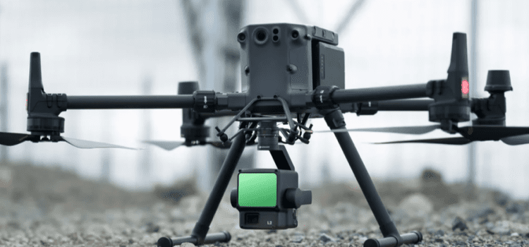
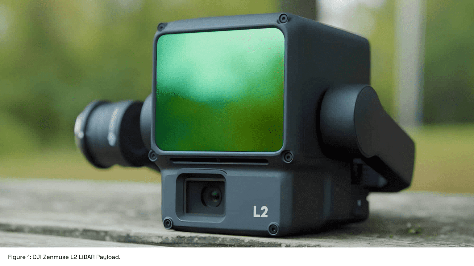
We opted to use the DJI Zenmuse L2 Livox scanner, a powerful but accessible LiDAR system that balances performance with ease of use. The L2 can collect up to 1,200,000 points per second, while simultaneously capturing 24MP RGB images for photogrammetric processing, making it a versatile tool for geospatial data collection.
To assess the real-world performance of LiDAR, we selected a range survey sites, each designed to highlight different strengths of the technology:
- An urban area next to the Thames in Rotherhithe, London, chosen to test LiDAR’s ability to map complex built environments.
- A rural railway corridor, where LiDAR’s high point density was used to capture fine details of rail infrastructure.
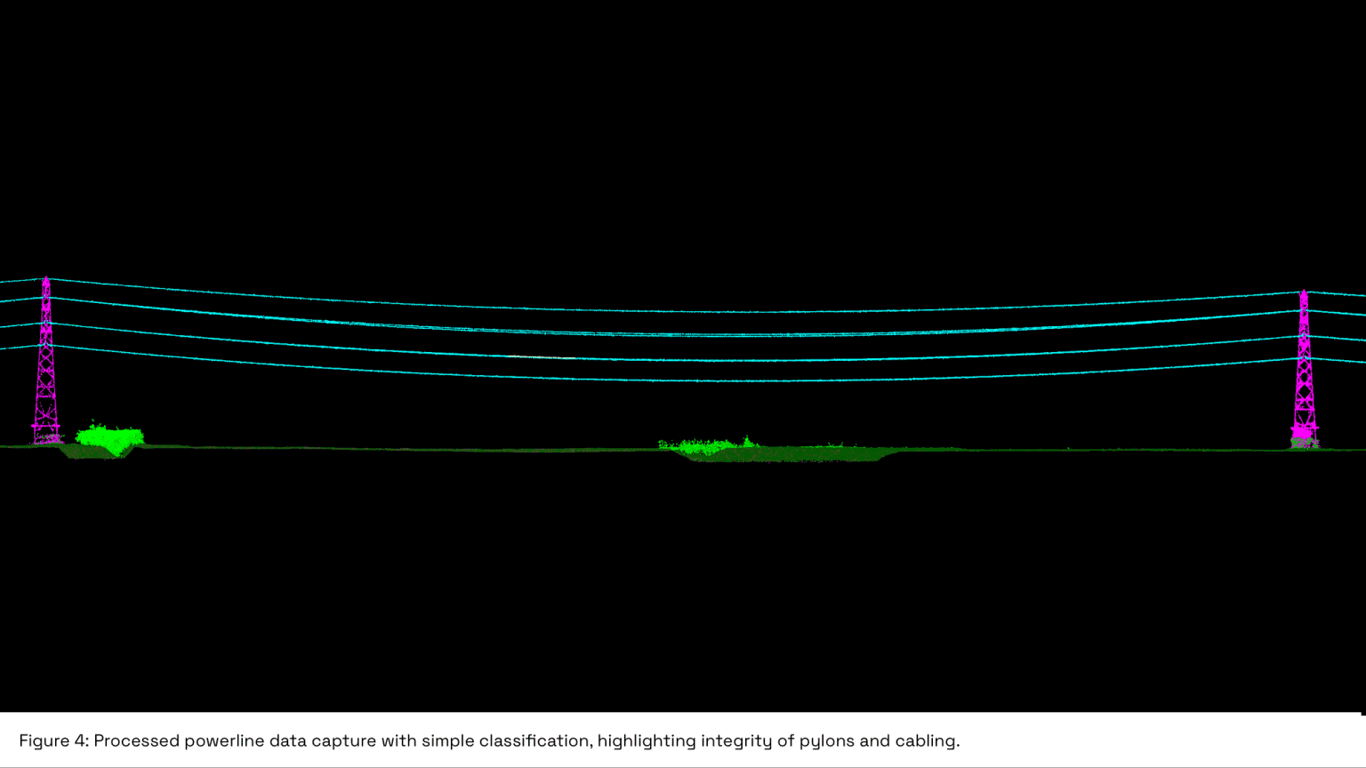
- A high-voltage powerline over farmland, to evaluate LiDAR’s effectiveness in detecting thin, elevated structures.
- Two rural field sites, selected to test LiDAR’s penetration through vegetation and capability to capture subtle topographic variations.
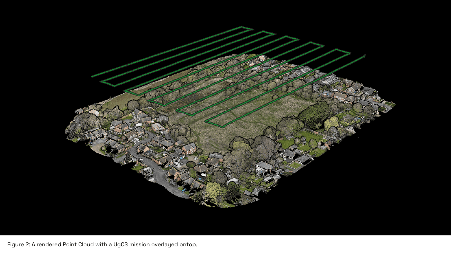
Before deploying to each site, detailed flight plans were created using UgCS flight planning software. This allowed us to optimise flight paths for LiDAR scanning, ensuring thorough coverage while incorporating the essential calibration patterns required for the DJI L2’s operations.
Capturing high-quality data requires a balance between understanding equipment limitations and adapting to external conditions. During our missions, factors such as wind speed, lighting conditions, and terrain complexity were carefully considered to maximise data accuracy.
Point Cloud Visualisation & Classification
After successfully capturing LiDAR data in the field, the next critical step is processing the raw point clouds into structured, accurate, and usable datasets.
LiDAR data consists of thousands of near-instantaneous laser scans, each measuring the time it takes for emitted pulses to reflect off surfaces and return to the sensor. This provides precise topographic data, but advanced processing is required to extract meaningful insights.
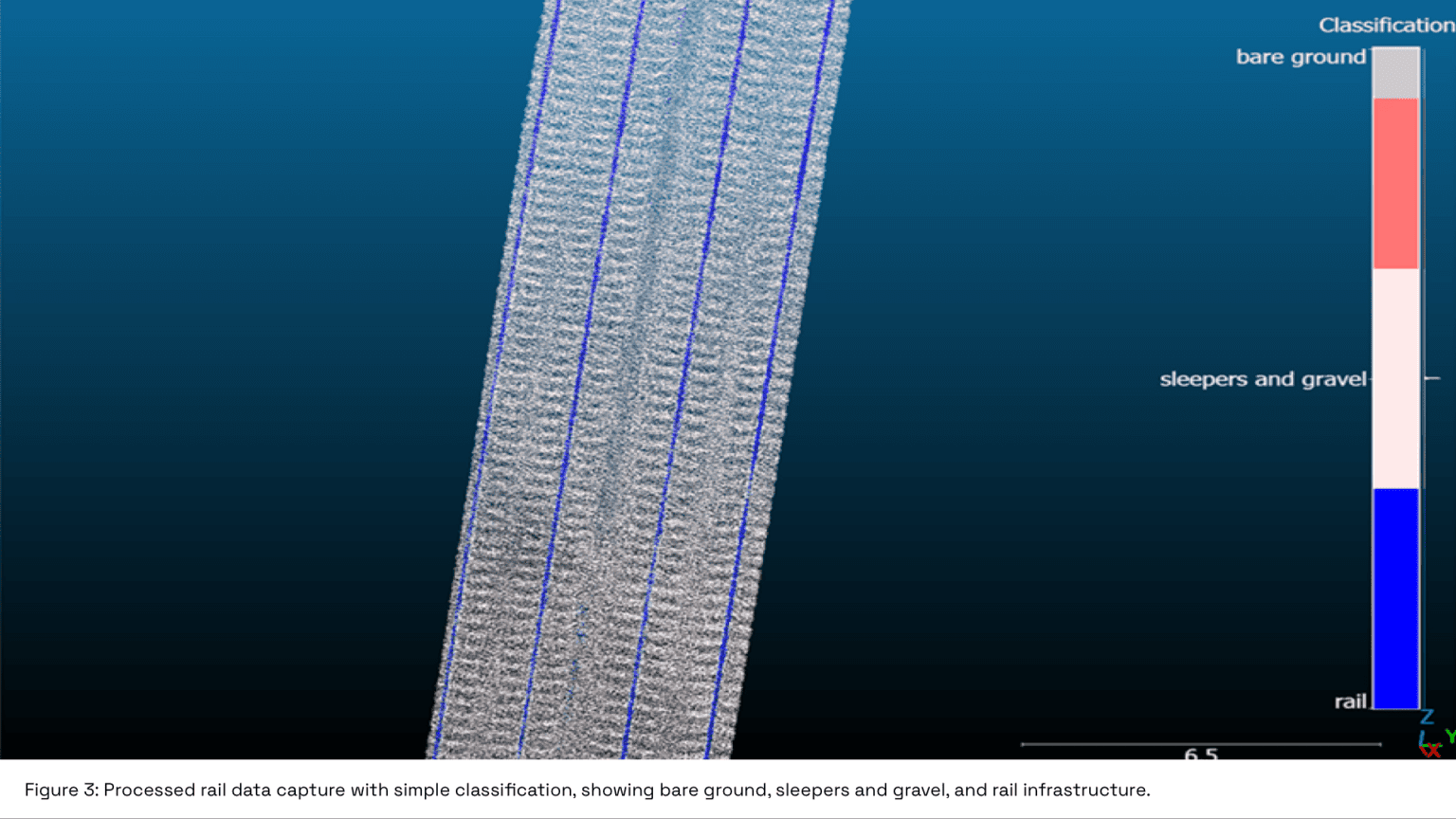
An example of this is our railway project, where the post classification process successfully divided the point cloud into distinct categories: rail tracks, sleepers & gravel, and bare ground.
Three key attributes determine how LiDAR data is processed and refined:
- Elevation & Surface Topology – highly detailed elevation models, even in areas with dense vegetation.
- Intensity Values – differentiation between surface types, as materials reflect light differently.
- Colourisation (RGB) – ability to assign RGB values to LiDAR points, improving feature classification and visualisation.
For this, we used an open-source point cloud processing tool that allows for greater control over data refinement. The processing workflow followed these key steps:
- Trimming & Pre-Processing – The point cloud was trimmed to focus only on the area of interest, removing unnecessary data points.
- Noise Reduction – Erroneous points (outliers, reflections, or atmospheric noise) were filtered out to improve accuracy.
- Classification & Segmentation – A machine-learning-based classification algorithm was trained to separate different surface types, such as:
- Bare ground (for topographic models)
- Infrastructure (rails, powerlines, buildings, roads, etc.)
- Vegetation layers (low, medium, and high canopy classification)
For the powerline survey, the algorithm was used to isolate the thin cabling from the surrounding landscape, something photogrammetry alone struggles to achieve.
Further Processing & Industry-Common Outputs
Processing LiDAR data is not just about generating and classifying a point cloud; it’s about transforming raw scans into structured, actionable datasets that meet the specific needs of different industries.
Based on the project requirements, LiDAR outputs can be processed into an wide array of data formats:
- Digital Elevation Models– DTM/DSMs
DEMs can be great tool for projects that require precise elevation data. Infrastructure & civic planning, environmental management and flood risk assessment are just some of the many applications.
Find out more about the use and benefits of Digital Elevation Models here.
- AutoCAD Outputs
Engineering and design applications require LiDAR data to be converted from point clouds into vector-based CAD models.
Translating topographic LiDAR data into a .DWG format produces an easy to interpret, fully annotated CAD file with elevation contours, breaklines, featured maps, and much more.
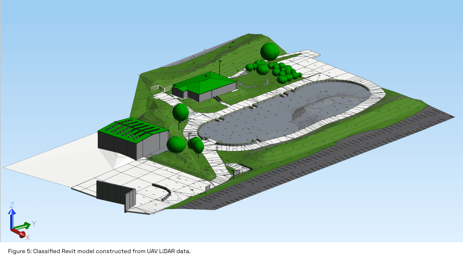
- Building Information Modelling
BIM and Revit models generated from point clouds generate highly detailed and accurate digital twin of a site. This gives professionals a comprehensive tool for long-term asset management, maintenance, and future development.
Conclusion
We successfully completed a wide range of UAV mapping missions with the DJI Zenmuse L2 LiDAR payload. This demonstrates our expertise in the capture and advanced processing of airborne LiDAR data.
These missions provided us with a fantastic opportunity to explore the capabilities of LiDAR. We have captured some incredible datasets that only scratch the surface of what’s possible with the technology.
Contact Us
At Survey Air, we offer specialist drone mapping services tailored for industry applications. This includes products such as 3D building models, 2D orthomosaic maps and volumetric assessments.
For more information on our UAV services, please contact our expert team today to request a free quote and consultation.