UK SORA & BVLOS Drone Operations Explained
In recent years, drone technology has rapidly advanced, enabling longer flight times, smarter sensors, and safer aircraft that are able to detect and avoid with increasing reliability. Unfortunately, despite these changes, the Civil Aviation Authority (CAA) drone regulations have struggled to keep pace.
Until recently, most pilots have had to fly missions in strict accordance with Predefined Risk Assessment 01 (PDRA01), with any flights requiring permissions beyond this having to go through the arduous process of applying for an Operational Safety Case (OSC).
The OSC has had great success in some settings, enabling operators to set up regular high-value missions that fly beyond the limits of PDRA01. For the average pilot however, the OSC process was lengthy, complex, and often expensive.
In April 2025, the CAA introduced the UK Specific Operations Risk Assessment (UK SORA) as a new framework for authorising drone operations in the Specific Category. The new SORA framework will allow operators to apply for permissions to fly more extensive missions like beyond visual line of sight (BVLOS) corridor flights, higher-altitude surveys over infrastructure, and operations closer to people or built-up areas where appropriate mitigations are in place.
Crucially, these missions are authorised on the basis of the operator’s ability to identify risks and demonstrate credible mitigations. In this blog post, we delve into the finer details:
- What is UK SORA?
- How will UK SORA affect drone pilots?
- How will Survey Air use UK SORA?
What is UK SORA?
Fundamentally, UK SORA is about understanding risk and showing how that risk will be managed. Instead of applying fixed PDRA rules that often felt restrictive, the new framework looks at the realities of each mission and breaks It down into two main sources of risk: air risk and ground risk.
Air Risk is the likelihood of encountering other airspace users such as helicopters or light aircraft. The CAA quantifies this by considering the type of airspace where the mission will take place, the altitude of the operation, and the expected density of manned traffic in that area. The higher the chance of coming into conflict with manned aircraft, the higher the air risk value assigned.
Ground Risk is the potential consequence of an incident occurring over people, property, or infrastructure. The CAA quantifies this by considering the type of environment beneath the flight path and the population density of the surrounding area. The more crowded or built-up the area, the higher the likelihood that an incident would have significant consequences, and therefore the higher the ground risk value assigned.
Once these intrinsic risks are calculated, operators are expected to set out what measures they will use to mitigate those risks. Trained observers, electronic conspicuity, and safety systems like emergency parachutes and many other mitigations all act to reduce the intrinsic risk. The end goal isn’t to eliminate risk entirely, but to demonstrate that it can be reduced to a safe and acceptable level.
This results in the Final Calculation for Air Risk and Ground Risk.
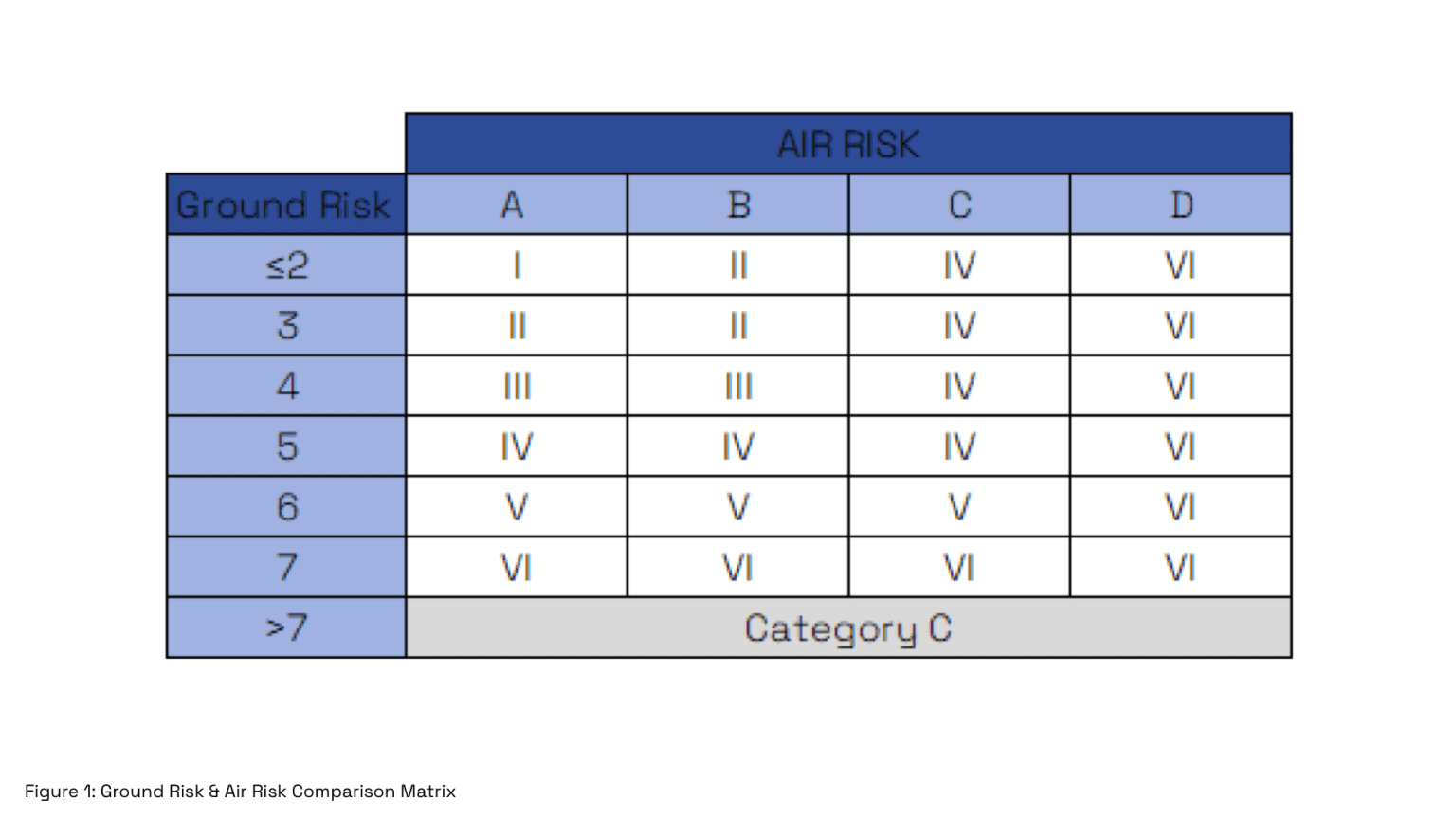
These two dimensions of risk are brought together in the risk matrix, shown in Figure 1. The matrix cross-references ground risk (rows) with the assessed level of air risk (columns) to produce an overall Specific Assurance and Integrity Level (SAIL). SAIL ranges from I to VI. Lower tiers in this range apply to simpler, low-risk flights and require only basic pilot competence, while medium levels demand more advanced training and operational safeguards.
The highest levels are reserved for complex, high-risk missions and call for extensive pilot certification, advanced safety systems, and strict compliance measures. As operators progress through these tiers, the scope of what they are authorised to do also broadens; from straightforward VLOS flights in rural areas through to BVLOS operations in controlled airspace and dense urban environments.
How will UK SORA affect drone pilots?
For pilots, the shift to UK SORA will mean a more structured pathway of training and certification. Currently, a single qualification, GVC or similar, is sufficient for most UAV operations, however drone pilots will now be expected to demonstrate competence that matches the SAIL tier that their mission falls into.
The CAA has introduced new Remote Pilot Certificates that align directly with the complexity of each tier:
RPC-L1:
The RPC-L1 certificate covers VLOS operations in low-risk environments. It requires at least two hours of practical training at a CAA-approved training centre and permits remote operations within the Specific Category but does not allow BVLOS flights. The certificate is valid for five years, after which a revalidation check is required before expiry. This is the new equivalent of a GVC and is the only tier open to under 18s.
RPC-L2:
The RPC-L2 certificate applies to more complex operations and permits basic BVLOS missions, if defined in the Operational Authorisation. It requires five hours of directed training in addition to at least 50 flight hours on a UAS of the same category. The certificate is valid for three years, with a currency requirement of at least two hours of flight time within the last 90 days.
RPC-L3:
The RPC-L3 certificate is for higher-risk BVLOS operations, including missions in controlled airspace assessed as ARC-c (Medium Risk) or near populated areas. In addition to all of the RPC-L2 requirements, pilots in this tier must also obtain a LAPL medical certification. This certificate will also have a 3-year validity.
RPC-L4:
The RPC-L4 certificate represents the highest level of competency, allowing high-risk BVLOS operations in complex environments such as controlled airspace up to (ARC-d) and densely populated areas. In addition to the requirements of RPC-L3, this competency tier requires significant training and a minimum of 75 BVLOS flight hours in the same UA category. RPC-L4 certificates must be renewed on a yearly basis.
At first glance, this may feel like an extra burden on pilots. But in reality, it creates a fairer system where training requirements scale with the risks of the mission.
Rather than over-training for simple flights or under-preparing for complex missions, pilots can now progress through a clear ladder of competence, gaining recognition as they move into more advanced areas of work.
Over time, this should raise professional standards across the industry, giving pilots more credibility, and providing clients with confidence that each operation has been matched to a proven level of training and assurance.
How will Survey Air use UK SORA?
At Survey Air, we cannot wait to start operating under UK SORA. For us, it represents a chance to expand the range of services we can offer and to deliver them with even greater efficiency, all without compromising on safety or quality.
Being able to operate BVLOS in rural environments without the complexity of applying for a OSC is a significant improvement for large scale drone mapping. We would be able to capture entire sites in a single seamless operation, rather than breaking a survey into multiple short flights with repeated take-offs, landings, and general repositioning.
BVLOS enables faster coverage, more consistent datasets, and fewer gaps or overlaps. The result is greater efficiency, reduced time on site, and more reliable outputs for our clients across every type of large-scale rural project.
UK SORA also brings far greater freedom in built-up environments, particularly for building inspection, scan-to-BIM and 3D modelling in city centres. Under PDRA-01, these operations are possible but highly restrictive, with the main limitation being overflight of uninvolved people. This makes it difficult to plan and execute surveys in dense urban areas, as flight paths must be tightly constrained and operations are often delayed until conditions are suitable.
With UK SORA, we can demonstrate compliance through the appropriate SAIL level and safety mitigations, allowing us to operate more flexibly in places like London, Birmingham & Manchester. This means we can deliver accurate drone surveys from roof and façade inspections to large-scale mapping and 3D modelling with fewer operational barriers, while still maintaining the highest standards of safety.
Conclusion
UK SORA is a huge step forward from the CAA and is finally cementing UAVs as a recognised entity in shared airspace. By matching training and mitigations to the actual level of risk, it not only raises standards the standards of pilots in the industry but also creates new opportunities for operators like Survey Air to deliver more ambitious projects.
From seamless rural BVLOS surveys to complex urban modelling, we will now be able to offer clients greater value with fewer restrictions, without compromising on safety or quality.
We’re excited to be part of this transition and look forward to seeing how UK SORA helps shape the future of safe, professional drone operations in the UK.
Contact Us
At Survey Air, we’re passionate about advancing the use of UAV technology and sharing our expertise to help clients unlock its full potential.
Whether you’re exploring the new UK SORA framework, planning your first BVLOS Operations, or looking to integrate drone data into your existing workflows, our team is here to guide you.
If you’d like to learn more about how these developments could benefit your projects, contact our specialists for an informal discussion, tailored advice, or a free initial consultation.